Color Tour :: Leelanau Enterprise, Autumn 2014
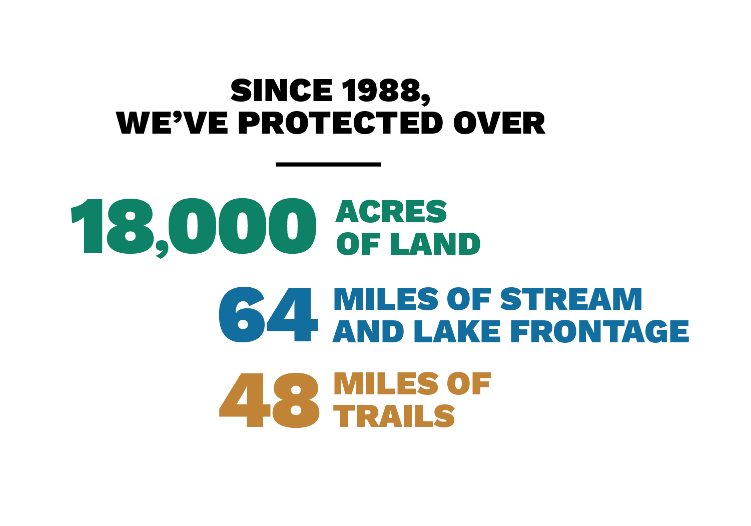
We love Leelanau in all its seasons, but there is something particularly magnificent about our peninsula during the peak of autumn color. We admire the hills aflame in golden hues, vistas from the Sleeping Bear Dunes National Lakeshore, wildlife in our peaceful County and State Parks, and pristine Leelanau Conservancy Natural Areas and Preserves.
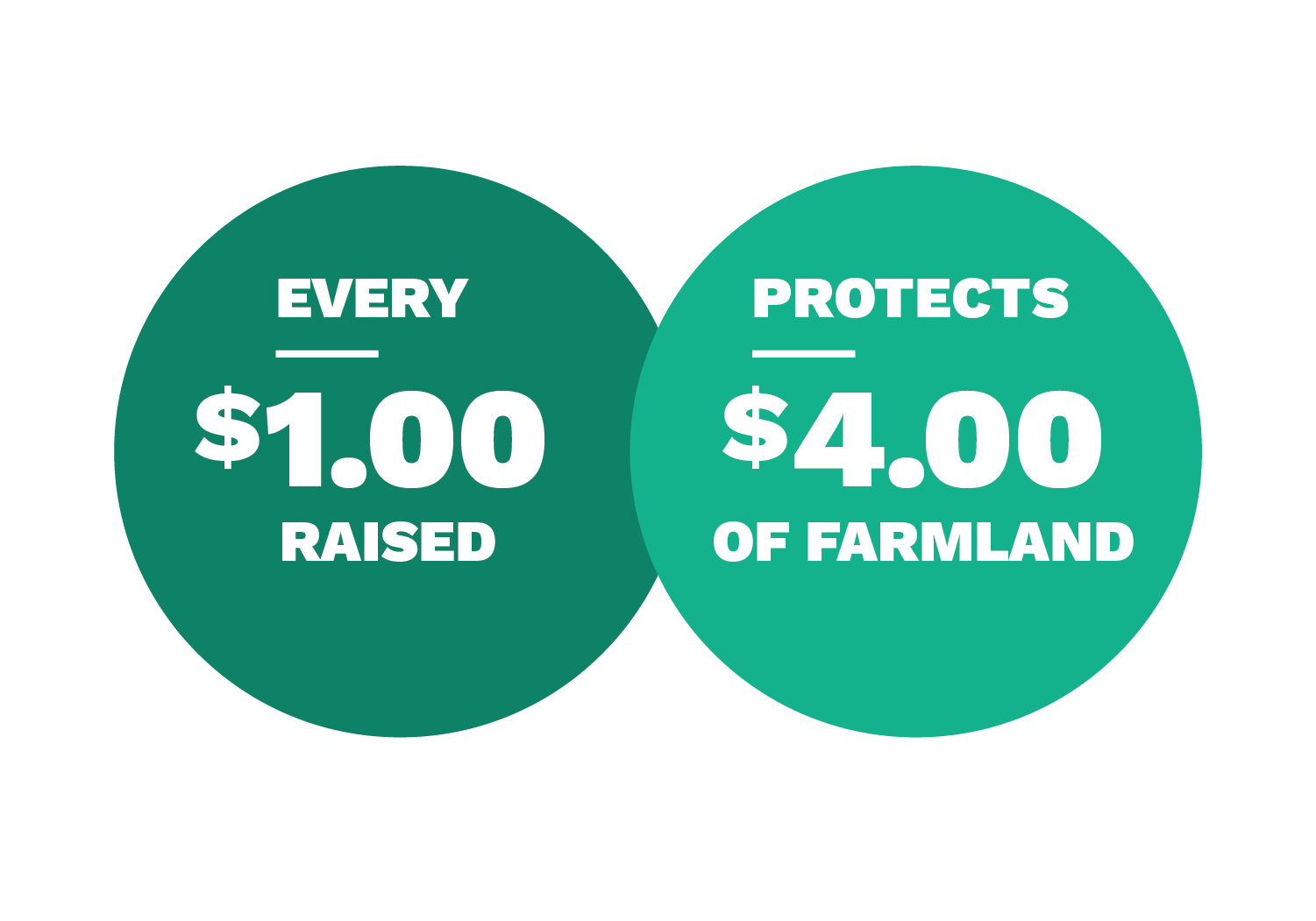
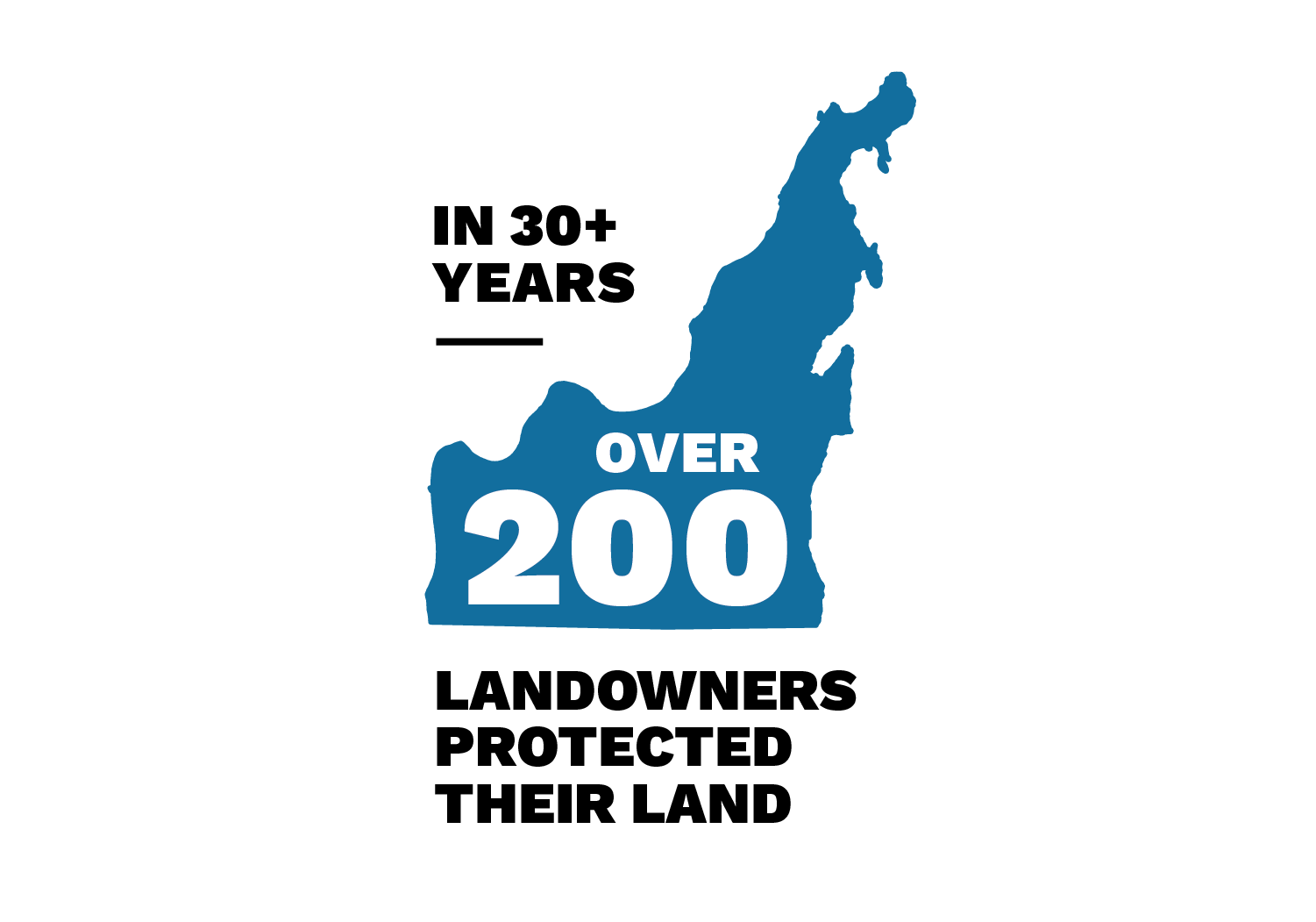
But as you drive along over winding roads and past scenic farmland, you may not realize that many privately owned lands in our County are also protected and will remain as they are now for generations to come. The Leelanau Conservancy uses many avenues of land protection, such as working with landowners to protect their land with private conservation easements; partnering with county, township, and state organizations; and tapping regional and federal funding for conservation projects.
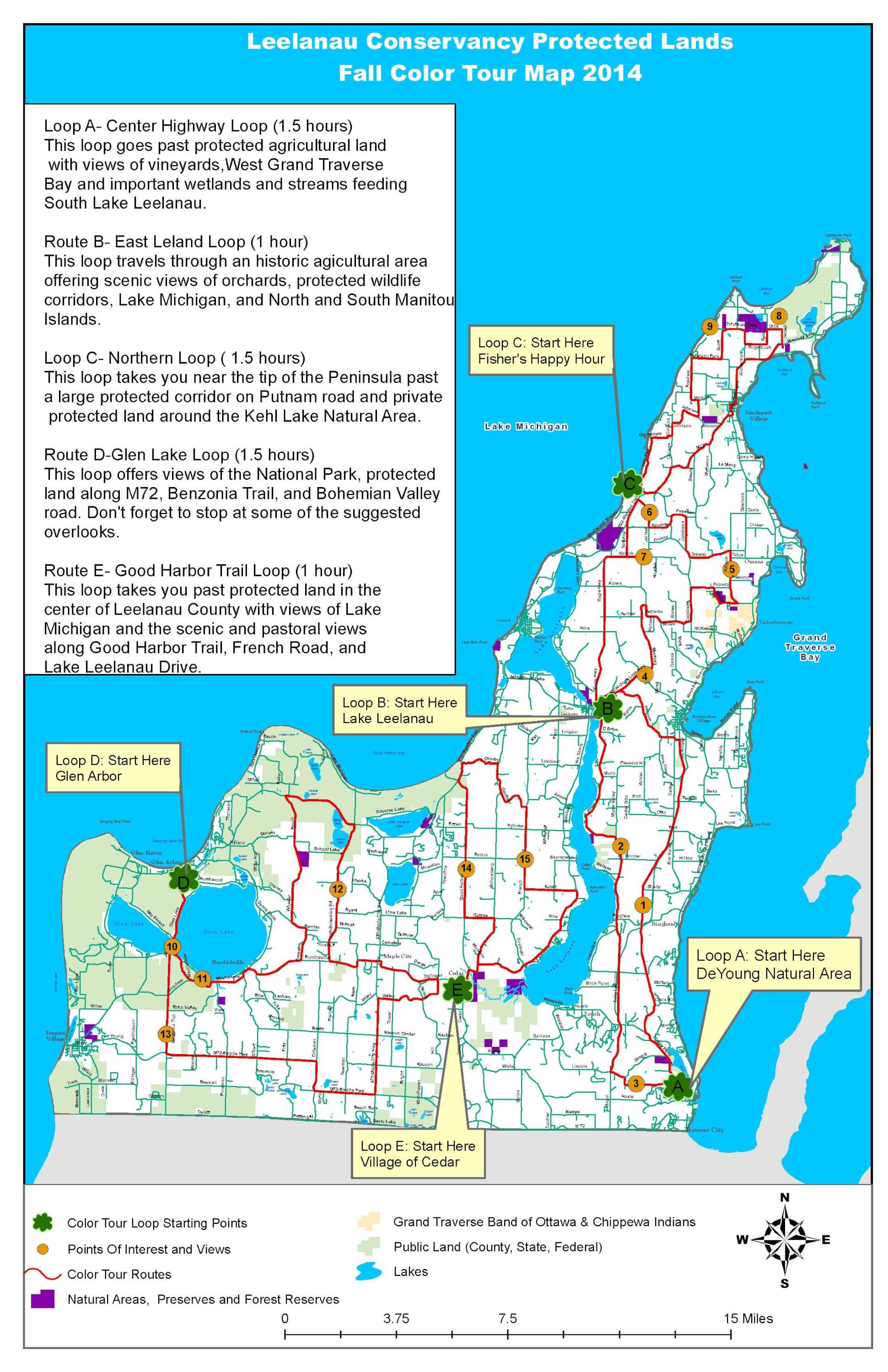
We welcome you to try a new color tour route this fall—one of our five loops on the map above —and take in the beauty of protected land on our peninsula. Please note: These scenic, sometimes winding, routes are best traveled with at least two people, a driver and a co-pilot.
Loop A :: Center Highway Route (approximately 1.5 hour)
- Begin at the DeYoung Farm on Cherry Bend Rd., a 160-acre Leelanau Conservancy Natural Area conserved in 2006 in partnership with Elmwood Township. The historic farmstead spreads across both sides of the road; and on the east side is a native cedar forest with a trail that leads to a fishing pier on Cedar Lake. 85 additional acres around Cedar Lake are protected with private conservation easements, resulting in a total of 2750 feet of protected shoreline.
- Head north on Cherry Bend Rd. and turn right onto Center Highway. Over 630 acres of land along Center Highway are protected with private conservation easements, including orchards and farmland on the beautiful rolling hills that stretch on both sides of the road as you travel through this agricultural corridor (RED DOT #1 ON MAP). Many of these farms have been protected with the assistance of the Federal Farm & Ranch Lands Protection Program, leveraged with funding from the Leelanau Conservancy.
- Make a right onto Richter Rd., then left onto Ecerle Rd. Another right onto Center Highway and a quick left onto Herman Rd. will take you past 126-acre Herman Community Park, a Suttons Bay Township recreational area. The Leelanau Conservancy contributed financially to this township-led project in 2009. This is an example of how the Leelanau Conservancy works with partners to assist with land projects.
- Continue on Herman Rd., winding up the hill and taking in the colors as you head north towards M-204. Turn left on M-204 and then left onto County Road 641. Enjoy the views along the south side of Lake Leelanau, including the wetland areas in Veronica Valley Park, a 92-acre County Park on your left. On the west side of the road (though not visible from the road) is the 174-acre Mebert Creek Natural Area, a Bingham Township Park that was created with the support of the Leelanau Conservancy in 1993 (RED DOT # 2 ON THE MAP). Mebert Creek Natural Area supports the health of the Lake Leelanau watershed and is accessible from the lake.
- Turn left onto Lincoln Rd. and take in a stunning view over Grand Traverse Bay, looking out over upland forests and and wetlands surrounding Cedar Lake. The forests in this area are critical for groundwater recharge and the health of the Grand Traverse Bay Watershed; 165 acres of land in this area are protected by private conservation easements, some of which were partially funded by a Clean Michigan Initiative Grant (RED DOT # 3 ON THE MAP).
- Follow Lincoln Road until you reach Cherry Bend Road; turn left onto Cherry Bend Road, wind around another beautiful forest edge, and you’ll soon find yourself back at the historic DeYoung Farmstead.
Loop B :: East Leland Route (approximately 1 hour)
- Start in Lake Leelanau and head east down M-204. Enjoy the views of orchards, vineyards, and upland forests as you pass through a corridor of protected land—690 acres of farm and natural lands are in private conservation easements along M-204 and adjacent roadways (RED DOT # 4 ON THE MAP). Turn left on Macksey and continue along past more conserved farmland.
- When Macksey makes a T with Setterbo, turn right onto Setterbo, then turn left on Solem. Solem will take you past more protected agricultural land, orchards, and lovely historic farmsteads. Turn left on Jacobson Rd. and then right on Pobuda Rd. Slow down and look for a scenic road on your right: Roubal. Turn right on Roubal Rd., a winding road that goes through mature forest and forest wetland and past the Leelanau Conservancy’s 68-acre Belanger Creek Preserve This Preserve is a natural land buffer that protects a high-quality brook trout stream.
- Turn left on Peshawbestown Rd. and then left onto Putnam Rd. Putnam Rd. will take you past privately conserved land on your left and Saving Birds Thru Habitat, a wildlife sanctuary, on your right (RED DOT # 5 ON THE MAP). Over 230 acres are privately protected along Putnam Rd .
- When Putnam meets Omena Rd., turn left onto Omena Rd. and then take a right onto Jacobson Rd. where you’ll go past more privately protected land as you head north. Then turn left on Peterson Rd. and left on Christianson Rd.
- Turn right onto Kovarik Rd., go around a bend, and prepare yourself for a stunning view over the Manitou Passage. Turn right onto Jelinek Rd. and go slowly so you can take in another sweeping view of farmland with a Lake Michigan backdrop (RED DOT # 6 ON THE MAP). Over 270 acres of land here, including area on both sides of Jelinek Rd., are protected with private conservation easements.
- When you get to the bottom of the hill, turn left onto M-22 and then make your way back up the hill by turning left on Novotny Rd. Look out the right side of your vehicle (if you are the passenger!) as you climb the hill and enjoy yet another view over protected land: 337-acre Houduk Dunes Natural Area in the distance and an additional 120 acres of privately protected land bordering Lake Michigan.
- Turn left onto Kolarik Rd. heading up towards St. Wenceslaus Church. This incredibly beautiful area deserves one more look — so turn around at St. Wenceslaus Church and head back west, down Kolarik Rd. the way you just came. Over 480 acres, encompassing land on both sides of the road, are privately preserved here (RED DOT # 7 ON THE MAP). And looking west, out in the distance you can see Lake Michigan, the tops of Whaleback and Pyramid Point, North Manitou Island, Lake Leelanau, and even the Leelanau Conservancy’s newest Natural Area: Clay Cliffs.
- Drive on to the bottom of the hill and turn left onto Eagle Highway. Follow Eagle Highway past east Leland farms, forests, and fields, including over 230 acres of privately protected land. Stay on Eagle Highway all the back to Lake Leelanau.
Loop C :: Northern Route (approximately 1.5 hour)
- Start at Fisher’s Happy Hour Tavern and head north on M-22. When you reach the outskirts of Northport, turn left on M-201 and go through the village where a private conservation easement protects a section of Northport Creek.
- Stay on M-201 until you reach Howell Rd. Turn left onto Howell Rd. (Howell Rd. comes up quickly on the left before Finton Natural Area (on the right) and Woolsey Airport (on the left)). Howell Rd. will turn left and become Ottis Rd.
- Follow Ottis Rd. until the T at Kehl Rd. The Leelanau Conservancy’s 279-acre Kehl Lake Natural Area is to your right, filled with majestic old-growth white pines in a towering mixed forest. In this area there are over 330 acres of privately protected land surrounding Kehl Lake Natural Area, resulting in an incredible wildlife corridor, especially for birds, near the tip of the peninsula (RED DOT # 8 ON THE MAP). Turn left onto Kehl Rd. and continue your way through crucial protected grasslands.
- Turn right on Sugarbush Rd. then right on Kilcherman Rd., which makes a left and becomes Christmas Cove Rd. If you need to stretch your legs, stay on Christmas Cove Rd. and go down a slight hill until you get to the road end beach. Hop out and walk down to Lake Michigan. Look toward the northeast, where over 200 acres of critical dunes are protected with township and Leelanau Conservancy private conservation easements (RED DOT # 9 ON THE MAP).
- Get back on Christmas Cove Rd., then turn right on Scott Rd. Turn right on Peterson Park Rd. Make a left onto Foxview Dr. where you will pass more rolling farmland, part of the northern edge of our abundant fruit belt. Foxview Dr. will make a left and turn into Melkild Rd.
- Continue on Melkild Rd. just briefly and then turn right onto Clausen Rd. At the T, turn right onto Johnson Rd., which will take you past Trillium Hill, a glorious forest to travel through in the fall as well as in the spring.
- Turn left onto Carlson Rd., then right onto Onomonee Rd. (there is no road sign here). If you’ve made it this far, you’ll be rewarded with a magnificent view of Lake Michigan spread out in front of you. Continue on Onomonee until you reach Gills Pier Rd. Turn left onto Gills Pier Rd. and make your way slowly down this scenic dirt road, back to where you began.
Loop D :: Glen Lake Route (approximately 1.5 hour)
- Start in Glen Arbor and head south on M-22 through the Glen Lake Narrows, enjoying gorgeous views of Sleeping Bear Dunes National Lakeshore (RED DOT # 10 ON THE MAP). Turn left on MacFarlane (County Rd. 616). As you weave your way up along the road surrounded by towering trees, look around at the upland forests that provide essential groundwater recharge for the Glen Lake Watershed. Over 300 acres of land in this watershed are privately protected, contributing to the exceptional quality of water in the streams and lakes.
- When you reach the top of the hill, stop at Inspiration Point, a scenic pull out in the National Lakeshore, to take in the view over Big Glen Lake, Little Glen Lake, Alligator Hill, and Lake Michigan (RED DOT # 11 ON THE MAP).
- Stay east on County Rd. 616 to Tremain Rd. Turn left on Tremain Rd. where you will pass by 70 acres of forest land protected by a private conservation easement. Turn right onto Wheeler Rd., which will take you past the 110-acre Krumweide Forest Reserve, land that is actively managed by the Leelanau Conservancy for sustainable timber harvest. Krumweide Forest Reserve also includes a challenging hiking trail open to the public. Take care as you drive along this scenic gravel road.
- Meander down Wheeler Rd., which ends at M-22. Then turn right and head east on M-22 through more beautiful National Lakeshore. Turn right onto Bohemian Rd. (County Road 669) where you’ll pass by School Lake on your right.
- As you come out of the forest, the next few miles of Bohemian Rd. are a scenic agricultural corridor with over 220 acres of privately protected land, encompassing farm fields and natural lands on both sides of the road (RED DOT # 12 ON THE MAP). The open lands along here are known for visiting sandhill cranes and other exceptional wildlife.
- Turn left onto County Road 616 towards Maple City, past Myles Kimmerly County Park. Go through Maple City and turn left onto Belinger Rd., heading east. Turn right on Valley Rd. and you’ll pass by 43 acres of land, crucial to the Lake Leelanau Watershed, preserved with a private conservation easement.
- Follow Belinger Rd. until it comes to Maple City Highway (County Rd. 667). Turn left onto Maple City Highway and then turn right onto M-72. In this area there are over 500 acres of privately protected land, both agricultural and natural, including a unique kettle hole, inland lakes, and scenic ridgeline.
- Stay on M-72 until you reach Benzonia Trl. (County Rd. 677). Turn right onto Benzonia Trl., heading north. If you need to stretch your legs, turn off at the scenic overlook (to your left as you crest the hill). Take in a magnificent view of the upland forests in the Glen Lake and Platte River Watersheds, much of which is in public and private protection.
- As you continue north on Benzonia Trl. you’ll pass by over 380 acres of land privately preserved by conservation easements (tucked behind National Park Land; not visible from this road). These undisturbed forests help promote upland water recharge and are a part of the healthy Glen Lake Watershed (RED DOT # 13 ON THE MAP). Enjoy the view as you descend towards Glen Lake, get back on M-22, heading through the narrows, and make your way back into Glen Arbor.
Loop E :: Good Harbor Route (approximately 1 hour)
- Start in downtown Cedar and head north on County Rd. 651. Turn right onto Schomberg Rd. (County Rd. 645) and you’ll pass the base of the 440-acre Cedar River Preserve on your right. This pristine wetland complex includes over 1000 acres of combined Leelanau Conservancy and State Forest land. 120 acres of the Leelanau Conservancy Preserve surround the mouth of the Cedar River—a crucial buffer for the health of the Lake Leelanau Watershed.
- As you continue to travel north on Schomberg Rd., you’ll pass over 40 acres of privately preserved land on your left. Enjoy the view coming up into Isadore and then turn left onto Gatske Rd.
- Turn right onto Good Harbor Trail (County Rd. 651). Enjoy the beautiful views as you drive north on Good Harbor Trail—along this stretch of road there are over 320 acres of land protected in private conservation easements (RED DOT # 14 ON THE MAP). Take in the patchwork of forests, wetlands, and farmland framed with a Lake Michigan backdrop as you wind your way down to M-22.
- Turn right onto M-22 and then take a slight right onto Overby Trl. Overby turns into a narrow, curvy gravel road at the top of the hill, so take care on your way up. When you come out of the woods at the top of the hill, you’ll pass over 170 acres of preserved agricultural land on your right and more preserved forested land stretching beyond the orchards.
- When Overby Trl. meets Shomberg Rd., turn right onto Schomberg Rd. Down the hill, Schomberg Rd. turns into Gauthier Rd. Stay on Gauthier as it winds down towards French Rd.
- Turn right onto French Rd. (County Rd. 645). This beautiful agricultural corridor contains over 560 acres of land preserved through private conservation easements, including pastoral views of orchard and farm landscapes (RED DOT # 15 ON THE MAP).
- Turn left on Kabat Rd. and look down upon Lake Leelanau. Turn right on Lake Shore Dr. (County Rd. 643) and wind your way around the western side of Lake Leelanau past more privately protected land in the wetland and stream corridors to the west, which are crucial to the health of Lake Leelanau.
- When County Rd. 643 meets Schomberg Rd. (County Rd. 645), turn left and make your way back to Cedar.